
Edit Surfaces - Perform Excavations and Dewatering in DeepEX
- Feb 6, 2024
- 4 min read
Updated: May 26, 2025
Surface Options - Excavations - Dewatering Operations in DeepEX software
In this article we will present all different ways to edit the surface points in DeepEX software, so we can easily create slope and bench surfaces. In addition, we will explain all the required tools in order to perform excavations and edit the water table graphically on the model area through constructon stages.
A. Edit Surface Options
In DeepEX software the local x-axis in each design section is along the screen. The x-coordinate 0 is by default the top left point of the main (left) wall.
In general, the surfaces on each wall side are continuous lines:
- The first line starts at the left model area limit and stops on the left wall left X coordinate (defined in the Edit Wall dialog that appears when you double-click on a wall, marked there as xWall).
- The second surface line starts from the inner wall X-coordinate, which is automatically generated and modified when we edit the wall section width. This coordinate is always xWall + Wall Thickness. The surface line stops either at the right model limit (when we use 1 wall in the model), or at the left point of the right wall.
When we modify the wall thickness, perform excavations etc, these points are automatically readjusted according to our modifications.
There are several ways to edit the ground surface lines in order to simulate the exact project surface. In general, it is recommended to keep the x-coordinates in order from left to right. Also, we should avoid totally vertical surfaces (two points with identical or very close X-coordinate and different elevations).
Edit the surface points manually
Along the main surface on the interactive model area there are surface points, which we can access (double-click on them) and define the x-coordinate and elevation of each point.
Edit the surface points using the table of coordinates tool
In the General tab of DeepEX, under the Surface Options selection, we can select to edit the table of coordinates. This option loads the table, in which we can locate all existing surface points, we can edit the X-coordinate and elevation of each point and we can choose to add new surface points (a new point is added right before the point we have selected before pressing to add a new one). This way, we can add several points and simulate a more composite ground surface. The first and last point of each surface line cannot be deleted from the table of coordinates, we need to adjust the point elevation to create the desired surface.

Create Slope or Bench Surfaces Automatically
DeepEX includes tools that allow us to create slope or bench surfaces on the left or right side of each wall automatically. These tools can be accessed either from the Surface Options selection in the General tab of the software, or by right-clicking with the mouse on the model area close to the surface that we wish to edit. In the dialog that appears when a tool is selected, we can select and define the surface or bench properties (slope angle, bench offset, bench elevation etc.).

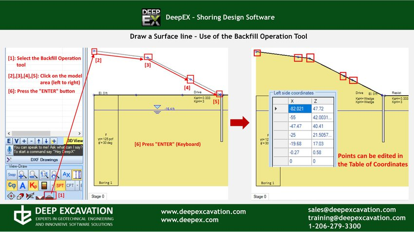
Add new Surface Points with the Backfill Operation Tool
From the toolbar on the left side of DeepEX main screen, right above the “Check model” option, we can access the backfill tool. With this tool, we can click on various points on the model area (from left to right), and after the last click press the “Enter” button from the keyboard. DeepEX will create the new ground surface, using the inserted points.
B. Excavations and Dewatering Operations
In each construction stage we can perform excavations, dewatering and backfill operations independently, by defining the ground surface elevations and water table. These operations can be done with the tools in DeepEX General tab and toolbar, or graphically on the model area.
Defining Exact Ground Surface and Water Elevations
In the General tab of DeepEX we can define the exact elevation of ground surface and water table for each wall side, in each construction stage. By changing the values in the boxes we can set the elevation in the specific stage, performing excavations, dewatering and backfill operations in comparison with the previous stage. By accessing the Ground Water Options table, we can define the exact water elevation on each wall side and choose to dewater automatically (option maintain at subgrade).
Excavating, Backfilling and Dewatering Graphically
In the interactive model area of DeepEX we can move the mouse over any ground surface or water line and drag-and-drop it, performing excavations, backfill or dewatering operations graphically.
Backfilling and Excavating with the Backfill Operation and Excavation tool
From the toolbar on the left side of DeepEX main screen, right above the “Check model” option, we can access the backfill and excavation tools. By accessing any of them, we can click on various points on the model area (from left to right), and after the last click press the “Enter” button from the keyboard. DeepEX will create the new ground surface, using the inserted points. In some cases, an attitional point might be generated at the end of each surface line, with the software automatically created last point (see A. above). In this case, we can simple access the Surface Table of Coordinates and edit the positions and elevations of all points.


Wish to Learn how to Create any Excavation Model in Minutes?
Book a FREE online presentation now!

DeepEX - Shoring Design Software
DeepEX is the ultimate software program for design and analysis of Deep Excavations! Design any wall type and support system in the most efficient way!
|
|
|
|
|
|

DeepEX Features
All software features and capabilities! Review all available design methods and analysis standards!

DeepEX Upgrades
We continue our research and we introduce new unique features that extend the software capabilities!

HoloDeepEX
Export and visualize 3D deep excavation models in Virtual and Augmented Reality! Impress your clients!
Projects designed with DeepEX
$2 Billion Hudson Yards, New York | Circular wet soil mix shaft, Florida | Soldier Pile Wall in Manhattan, NY |
 |  |  |
Trusted by


